Historical background
Underwater campaigns from 1997 to 2005 documented prehistoric remains. The settlement was reconstructed in 2007–2008 as an accessible presentation of finds from beneath the lake.
Lake Ohrid · Nearby guide
Reconstructed stilt houses and underwater archaeology
📍 Gradište, Peštani · Ohrid 6000, North Macedonia
The museum publishes seasonal hours and is generally closed Mondays; confirm holidays or maintenance on its official site.
Open this place on Google Maps ↗Explore the place
Near Gradište on the southern shore of Lake Ohrid, a walkway leads into a reconstructed prehistoric lake settlement. Its platforms and huts demonstrate how Late Bronze and Early Iron Age communities lived above the water.
Bay of Bones turns underwater archaeological research into a walkable interpretation of prehistoric lake life. A wooden bridge leads to a raised platform and reconstructed huts. The most revealing detail is how houses, circulation and lakeshore livelihoods fit together—not simply the photogenic setting.
The Museum on Water at Bay of Bones is presented and overseen by the National Institution Institute for Protection of Monuments of Culture and Museum – Ohrid, responsible for researching, conserving and exhibiting the region’s heritage. Consult its official notices for visiting arrangements.
Check source ↗Study how timber piles support the reconstructed platform
Compare house materials and small domestic interiors
Look for references to pottery, stone tools and underwater archaeology
The museum lists its address as Village of Peshtani, Gradishte, 6000 Ohrid. Additional archaeological displays and the hillside site are subject to the museum’s current opening arrangements.
Underwater campaigns from 1997 to 2005 documented prehistoric remains. The settlement was reconstructed in 2007–2008 as an accessible presentation of finds from beneath the lake.
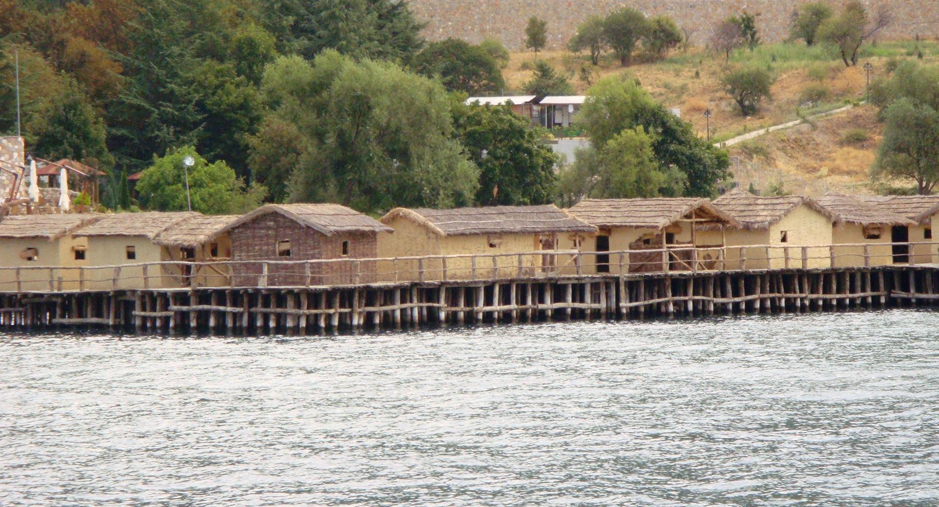
Timber piles and an elevated wooden platform support reconstructed houses using wood, clay and thatch. Later defensive remains are also presented on the hillside.
The walkway offers lake and mountain perspectives. Keep behind barriers and avoid touching fragile displays.
The display interprets a Late Bronze to Early Iron Age lakeside community. Underwater piles and household artefacts reveal how people adapted to the water. The visible huts are modern reconstructions based on evidence, not surviving original houses.
Look from the house floors down to the piles beneath, then return to shore to see the platform as a whole. Spacing of supports, floor elevation and clustered roof forms explain more than a single panoramic image.
Suggested order: entrance panels → underwater archaeology interpretation → boardwalk → reconstructed hut interiors and exteriors → shore panorama → continue toward St Naum.
Read the entrance interpretation to understand the timeline
Follow the walkway and compare the huts and platform
Step back on shore for a full view of the settlement over the water
Ohrid town makes a practical overnight base for a half- or full-day journey along the southern lakeshore. Check seasonal boats, parking and return transport in advance.
Use this place’s own Google Maps listing for recent visitor reviews. No unverified rating is displayed here.
Open this place on Google Maps ↗No. The visible structures reconstruct the settlement based on underwater archaeological evidence.
Yes, both lie along the southern shore route; allow time for transport.
The exposed wooden walkway may be slippery; follow museum instructions in bad weather.
On the lakeside road at Gradište south of Peštani; a logical stop on the road to St Naum.
Gradište, Peštani · Ohrid 6000, North Macedonia
Open this place on Google Maps ↗